Pobierz prezentację
Pobieranie prezentacji. Proszę czekać

1
Metody teledetekcyjne w badaniach atmosfery i oceanów. Wykład 7b MSG
Krzysztof Markowicz

2
Historia funkcjonowania satelitów Meteosat
Satelity Meteosat pierwszej generacji: Meteosat Meteosat Meteosat Meteosat Meteosat Meteosat Meteosat Satelity Meteosat drugiej generacji (MSG): Meteosat Meteosat
: Meteosat Meteosat")
4
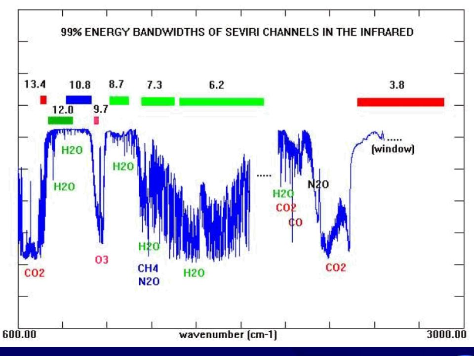
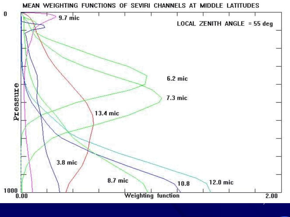
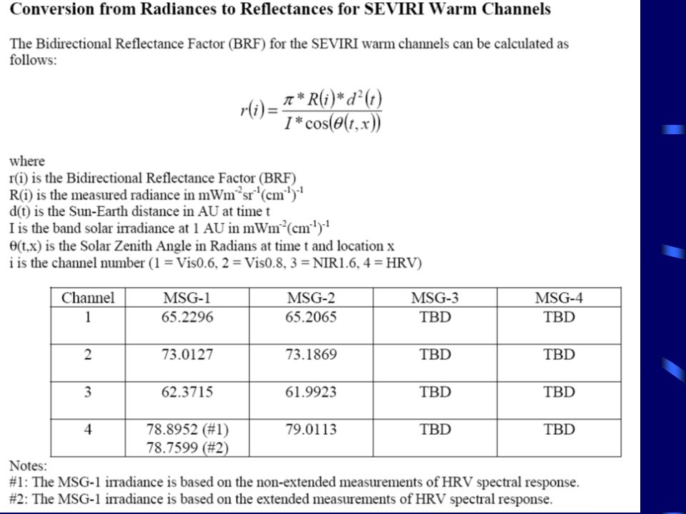
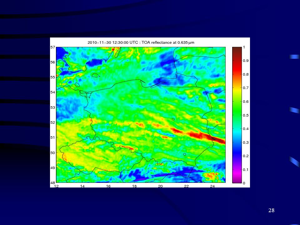
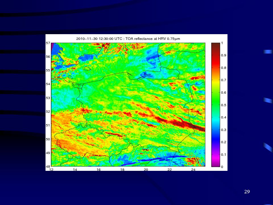
Channel & wavelength (microns)
Spectral Band upper-lower wavelengths (microns) Spatial Resolution (kilometers) Principal Sensitivity HRV 0.75 1 km cloud texture, winds VIS 0.64 3 km cloud over land, winds VIS 0.81 cloud over water, vegetation NIR 1.6 cloud over snow MIR 3.8 low cloud IR 6.2 high water vapor IR 7.3 middle water vapor IR 8.7 total water vapor IR 9.7 total ozone IR 10.8 surface & cloud top temp., winds IR 12.0 surface temp. correction IR 13.4 higher clouds Channel Wavelength (microns) Spectral Band upper-lower Wavelengths Spatial Resolution (kilometers) Principal Sensitivity HRV 0.75 1 km cloud texture, winds VIS 0.64 3 km cloud over land, winds VIS 0.81 cloud over water, vegetation NIR 1.6 cloud over snow MIR 3.8 low cloud IR 6.2 high water vapor IR 7.3 middle water vapor IR 8.7 total water vapor IR 9.7 total ozone IR 10.8 surface & cloud top temp., winds IR 12.0 surface temp. correction IR 13.4 higher clouds
 Spatial Resolution (kilometers) Principal Sensitivity. HRV km. cloud texture, winds. VIS km. cloud over land, winds. VIS cloud over water, vegetation. NIR cloud over snow. MIR low cloud. IR high water vapor. IR middle water vapor. IR total water vapor. IR total ozone. IR surface & cloud top temp., winds. IR surface temp. correction. IR higher clouds. Channel. Wavelength. (microns) Spectral Band. upper-lower. Wavelengths. Spatial Resolution (kilometers) Principal Sensitivity. HRV km. cloud texture, winds. VIS km. cloud over land, winds. VIS cloud over water, vegetation. NIR cloud over snow. MIR low cloud. IR high water vapor. IR middle water vapor. IR total water vapor. IR total ozone. IR surface & cloud top temp., winds. IR surface temp. correction. IR higher clouds.")
5
Meteosat 8-9, skaner SEVIRI

9
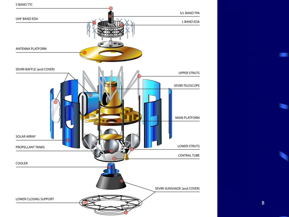
Schemat układu optycznego

11
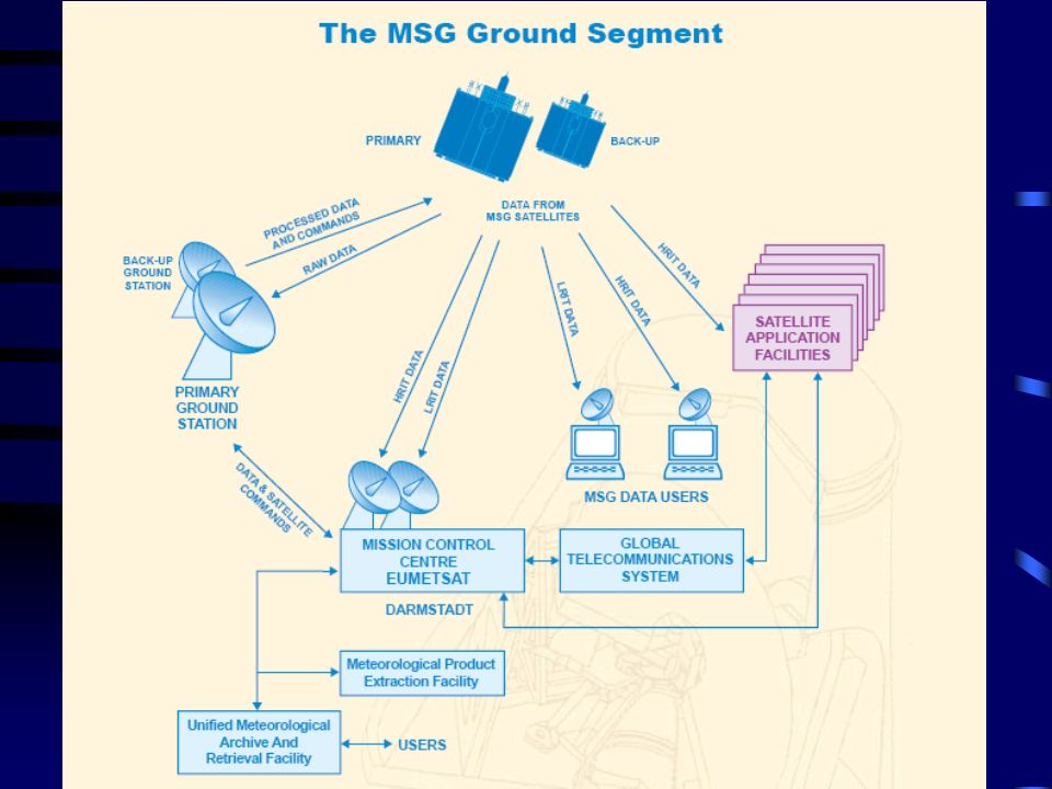
Typy danych: HRIT - High Rate Information Transmission LRIT - Low Rate Information Transmission

12
Produkty meteorologiczne
Profil wektora wiatru na podstawie ruchu chmur oraz gazów slajdowych (para wodna, ozon) Analiza zachmurzenia, wysokość i typ zachmurzenia Wilgotność w średniej i wyższej troposferze Precipitation Index Wysokość wierzchołka chmur (lotnictwo) Promieniowanie dla czystego nieba (numeryczne prognozy pogody) Masy powietrza Dane dla ISCCP (International Satellite Cloud Climatology Project) Całkowita zawartość ozonu w pionowej kolumnie Kalibracja
 Analiza zachmurzenia, wysokość i typ zachmurzenia. Wilgotność w średniej i wyższej troposferze. Precipitation Index. Wysokość wierzchołka chmur (lotnictwo) Promieniowanie dla czystego nieba (numeryczne prognozy pogody) Masy powietrza. Dane dla ISCCP (International Satellite Cloud Climatology Project) Całkowita zawartość ozonu w pionowej kolumnie. Kalibracja.")
13
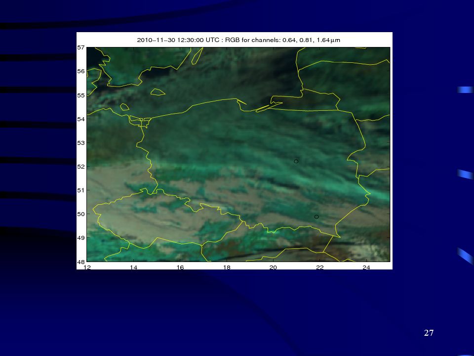
Earth Surface Channel 01 (VIS0.6) Clouds
High reflectance Very thick clouds Very thin clouds over land Very thin clouds over ocean Low reflectance Sun Glint Snow Desert Bare Soil Forest Ocean, Sea Jochen Kerkmann (EUMETSAT)
")
14
Earth Surface Channel 02 (VIS0.8) Clouds
High reflectance Very thick clouds Very thin clouds over land Very thin clouds over ocean Low reflectance Sun Glint Snow Desert Gras, Rice fields Forest Bare Soil Ocean, Sea Jochen Kerkmann (EUMETSAT)
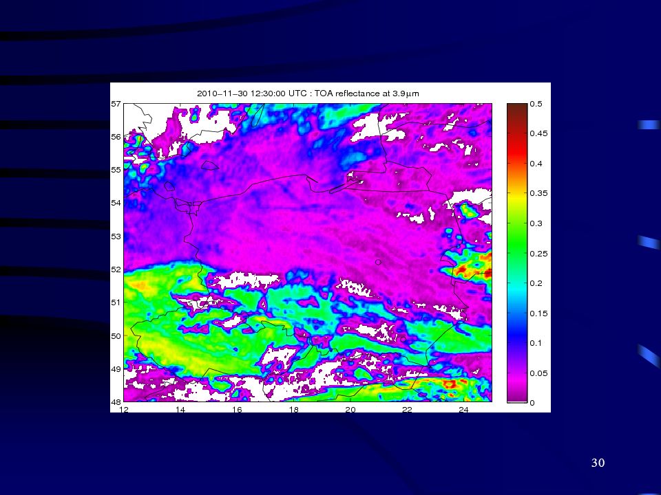
")
15
Earth Surface Channel 03 (NIR1.6) Clouds
High reflectance Water clouds with small droplets Water clouds with large droplets Ice clouds with small particles Ice clouds with large particles Low reflectance Sun Glint Sand Desert Gras, Rice fields Forest Bare Soil Snow Ocean, Sea Jochen Kerkmann (EUMETSAT)
")
16
Earth Surface Channel 04 (IR3.9) Clouds Daytime
High reflectance / Warm Low-level Water Clouds (land) Low-level Water Clouds (sea) Cold Ice Clouds (small particles) Cold Ice Clouds (large particles) Low Reflectance / Cold Sun Glint Fires Hot Sand Desert Warm Tropical Areas Cold Land Ocean, Sea Cold Snow Jochen Kerkmann (EUMETSAT)
 Low-level Water Clouds (sea) Cold Ice Clouds (small particles) Cold Ice Clouds (large particles) Low Reflectance / Cold. Sun Glint. Fires. Hot Sand Desert. Warm Tropical Areas. Cold Land. Ocean, Sea. Cold Snow. Jochen Kerkmann (EUMETSAT)")
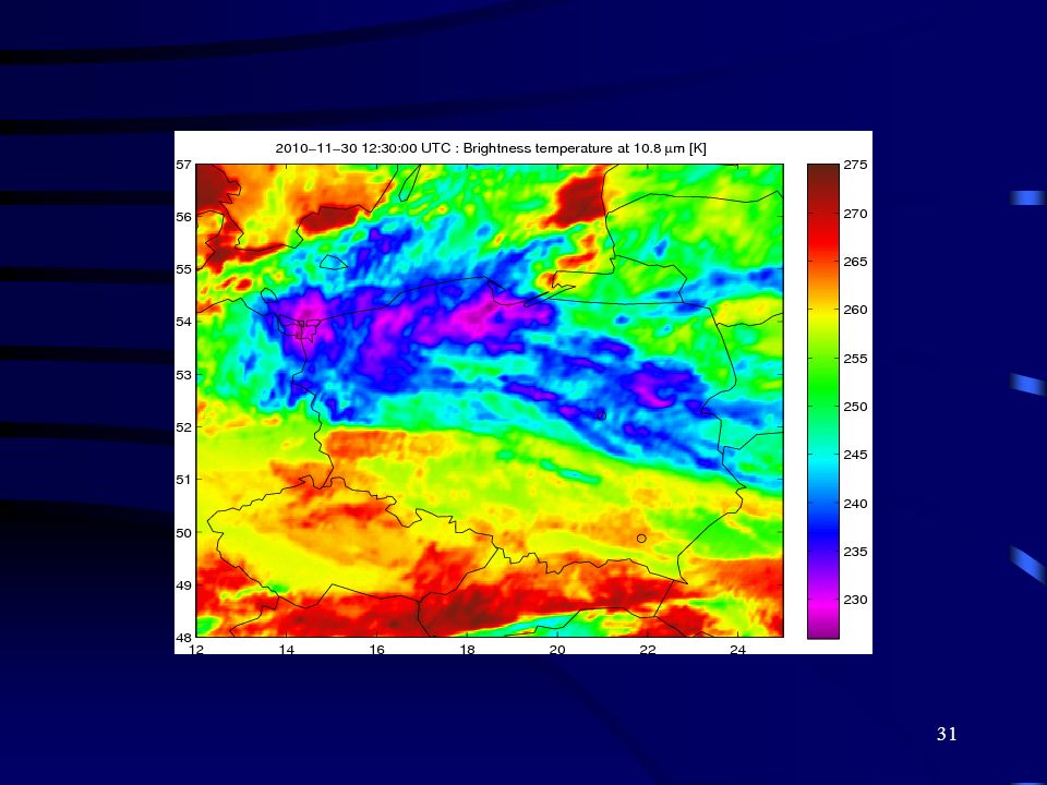
17
Earth Surface Channel 04 (IR3.9) Clouds Nighttime
Warm Low-level Clouds Mid-level Clouds High-level Clouds Cold Fires Warm Surfaces (tropical oceans, seas, lakes) Cold Surfaces (arctic ice areas) Jochen Kerkmann (EUMETSAT)
 Cold Surfaces (arctic ice areas) Jochen Kerkmann (EUMETSAT)")
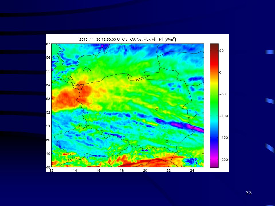
18
Water Vapour Channel 05 (WV6.2) Clouds
Warm High-level Clouds Cold Low UTH High UTH Jochen Kerkmann (EUMETSAT)
")
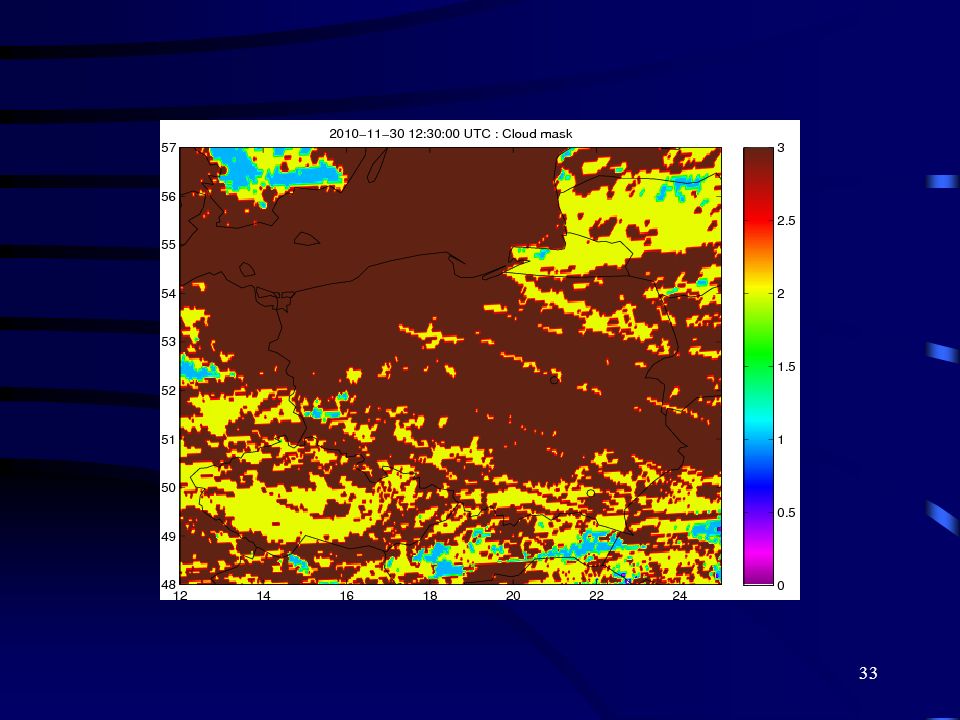
19
Water Vapour Channel 06 (WV7.3) Clouds
Warm Mid-level Clouds High-level Clouds Cold Low MTH High MTH (High-level warm surfaces) Jochen Kerkmann (EUMETSAT)
 Jochen Kerkmann (EUMETSAT)")
20
Earth Surface Channel 07 (IR8.7) Clouds
Warm Low-level Clouds Mid-level Clouds High-level Clouds Cold Hot Land Surf. Warm Sea Surf. (tropical oceans, seas, lakes) Cold Land Surf. (arctic ice areas) Jochen Kerkmann (EUMETSAT)
 Cold Land Surf. (arctic ice areas) Jochen Kerkmann (EUMETSAT)")
21
Earth Surface Channel 08 (IR9.7) Clouds
Warm Low-level Clouds Mid-level Clouds High-level Clouds Cold Hot Land Surf. Warm Sea Surf. (tropical oceans, seas, lakes) (Areas of high IPV) Cold Land Surf. (arctic ice areas) Jochen Kerkmann (EUMETSAT)
 (Areas of high IPV) Cold Land Surf. (arctic ice areas) Jochen Kerkmann (EUMETSAT)")
22
Earth Surface Channel 09 (IR10.8) Clouds
Warm Low-level Clouds Mid-level Clouds High-level Clouds Cold Hot Land Surf. Warm Sea Surf. (tropical oceans, seas, lakes) Cold Land Surf. (arctic ice areas) Jochen Kerkmann (EUMETSAT)
 Cold Land Surf. (arctic ice areas) Jochen Kerkmann (EUMETSAT)")
23
Earth Surface Channel 10 (IR12.0) Clouds
Warm Low-level Clouds Mid-level Clouds High-level Clouds Cold Hot Land Surf. Warm Sea Surf. (tropical oceans, seas, lakes) Cold Land Surf. (arctic ice areas) Jochen Kerkmann (EUMETSAT)
 Cold Land Surf. (arctic ice areas) Jochen Kerkmann (EUMETSAT)")
24
Earth Surface Channel 11 (IR13.4) Clouds
Warm Low-level Clouds Mid-level Clouds High-level Clouds Cold Hot Land Surf. Warm Sea Surf. (tropical oceans, seas, lakes) Cold Land Surf. (arctic ice areas) Jochen Kerkmann (EUMETSAT)
 Cold Land Surf. (arctic ice areas) Jochen Kerkmann (EUMETSAT)")
25
Earth Surface Channel 12 (HRV) Clouds
High reflectance Very thick clouds Very thin clouds over land Very thin clouds over ocean Low reflectance Sun Glint Snow Desert Bare Soil Forest Ocean, Sea Jochen Kerkmann (EUMETSAT)
")
26
Kompozycja barwna RGB uzyskana na podstawie pomiarów przyrządem SEVIRI na satelicie MSG2 o godzinie 06 UTC (a), 12 UTC (b), 16 UTC (c) dnia 16 kwietnia oraz o 12 UTC 17 kwietnia. Odcienie żółte odpowiadają pyłowi wulkanicznemu znajdującemu się ponad obszarem pokrytym chmurami. Barwy niebieskie oznaczają chmury zbudowane z kryształów lody, czerwone chmury zbudowane z kropelek wody, kolorem czarnym i brązowym oznaczone są obszary pozbawione zachmurzenia.

34
Xrit2pic – program do czytania danych MSG

Podobne prezentacje
, gdzie X jest liczbą osób w rodzinie, a Y liczbą izb w mieszkaniu. Niech f.r.p. tej zmiennej.>")


