Pobierz prezentację
Pobieranie prezentacji. Proszę czekać

1
Astrofizyka z elementami kosmologii
Temat 06: Układ Planetarny T.J. Jopek IOA UAM Tel Kom

2
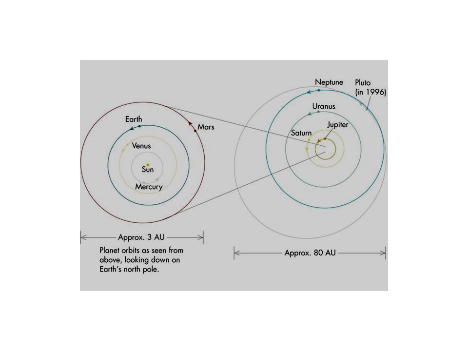
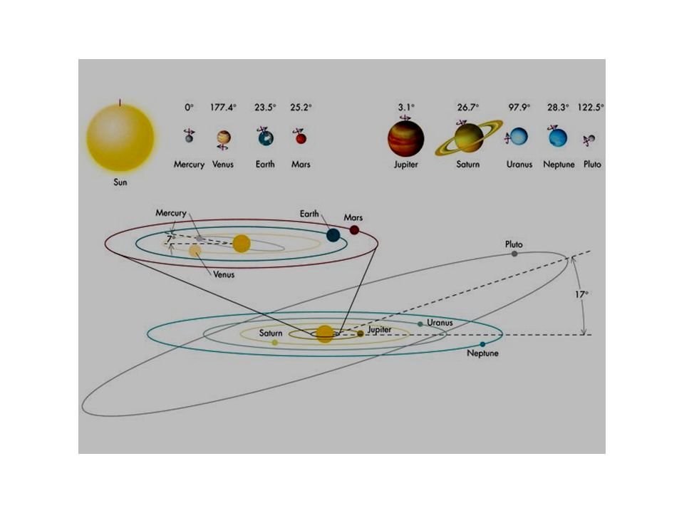
Układ Planetarny UP – jest układem płaskim można go zamknąć w płaskim pudle na kapelusze.

3
Układ Planetarny. Planety wewnętrzne

4
Duże obiekty Układu Słonecznego
Średnie odległości od Słońca w JA (jednostka astronomiczna). Merkury Wenus Ziemia Mars Jowisz Saturn Uran Neptun Pluton 0.387 0.723 1 1.524 5.203 9.539 19.18 30.06 39.53
. Merkury. Wenus. Ziemia. Mars. Jowisz. Saturn. Uran. Neptun. Pluton")
5
Merkury Średnica [km] Masa [kg] Vesc [km/s] Ok. rot. [doba]
Ok. obie. [doba] Temp [K] a [JA] 4878 3.3*10^23 4.3 58.65 87.98 452 0.387 Merkury Mass (kg) x 10^23 Diameter (km) Mean density (kg/m^3) Escape velocity (m/sec) Average distance from Sun (AU) Rotation period (length of day) (in Earth days) Revolution period (length of year) (in Earth days) Obliquity (tilt of axis) (degrees) Orbit inclination (degrees) Orbit eccentricity Mean surface temperature (K) Maximum surface temperature (K) Minimum surface temperature (K) Visual geometric albedo Largest known surface feature Caloris Basin (1350 km diameter) Atmospheric components trace amounts of hydrogen and helium Surface materials basaltic and anorthositic rocks and regolith Mariner 10 (1974)
![Merkury Średnica [km] Masa [kg] Vesc [km/s] Ok. rot. [doba]](http://slideplayer.pl/slide/417133/1/images/5/Merkury+%C5%9Arednica+%5Bkm%5D+Masa+%5Bkg%5D+Vesc+%5Bkm%2Fs%5D+Ok.+rot.+%5Bdoba%5D.jpg "Ok. obie. [doba] Temp [K] a [JA] *10^ Merkury. Mass (kg) x 10^23. Diameter (km) Mean density (kg/m^3) Escape velocity (m/sec) Average distance from Sun (AU) Rotation period (length of day) (in Earth days) Revolution period (length of year) (in Earth days) Obliquity (tilt of axis) (degrees) Orbit inclination (degrees) Orbit eccentricity Mean surface temperature (K) Maximum surface temperature (K) Minimum surface temperature (K) Visual geometric albedo Largest known surface feature Caloris Basin (1350 km diameter) Atmospheric components trace amounts of hydrogen and helium. Surface materials basaltic and anorthositic rocks and regolith. Mariner 10 (1974)")
6
Powierzchnia Merkurego: morza, urwiska, kratery, ... .

7
Merkury Średnica [km] Masa [kg] Vesc [km/s] Ok. rot. [doba]
Ok. obie. [doba] Temp [K] a [JA] 4878 3.3*10^23 4.3 58.65 87.98 452 0.387 Merkury
![Merkury Średnica [km] Masa [kg] Vesc [km/s] Ok. rot. [doba]](http://slideplayer.pl/slide/417133/1/images/7/Merkury+%C5%9Arednica+%5Bkm%5D+Masa+%5Bkg%5D+Vesc+%5Bkm%2Fs%5D+Ok.+rot.+%5Bdoba%5D.jpg "Ok. obie. [doba] Temp [K] a [JA] *10^ Merkury.")
8
Wenus Lądownik BEHEPA (1975?) Średnica [km] Masa [kg] Vesc [km/s]
Ok. rot. [doba] Ok. obie [doba] Temp [K] a [JA] 12104 4.87*10^24 10.4 243.0 224.7 726 0.723 Wenus Mass (kg) x 10^24 Diameter (km) Mean density (kg/m^3) Escape velocity (m/sec) Average distance from Sun (AU) Rotation period (length of day) (in Earth days) (retrograde) Revolution period (length of year) (in Earth days) Obliquity (tilt of axis) (degrees) Orbit inclination (degrees) Orbit eccentricity Mean surface temperature (K) Visual geometric albedo Highest point on surface Maxwell Montes (17 km above mean planetary radius) Atmospheric components % carbon dioxide, 3% nitrogen, 0.1% water vapor Surface materials basaltic rock and altered materials Lądownik BEHEPA (1975?)
![Wenus Lądownik BEHEPA (1975 ) Średnica [km] Masa [kg] Vesc [km/s]](http://slideplayer.pl/slide/417133/1/images/8/Wenus+L%C4%85downik+BEHEPA+%281975+%29+%C5%9Arednica+%5Bkm%5D+Masa+%5Bkg%5D+Vesc+%5Bkm%2Fs%5D.jpg "Ok. rot. [doba] Ok. obie [doba] Temp [K] a [JA] *10^ Wenus. Mass (kg) x 10^24. Diameter (km) Mean density (kg/m^3) Escape velocity (m/sec) Average distance from Sun (AU) Rotation period (length of day) (in Earth days) (retrograde) Revolution period (length of year) (in Earth days) Obliquity (tilt of axis) (degrees) Orbit inclination (degrees) Orbit eccentricity Mean surface temperature (K) Visual geometric albedo Highest point on surface Maxwell Montes (17 km above mean planetary radius) Atmospheric components % carbon dioxide, 3% nitrogen, 0.1% water vapor. Surface materials basaltic rock and altered materials. Lądownik BEHEPA (1975 )")
9
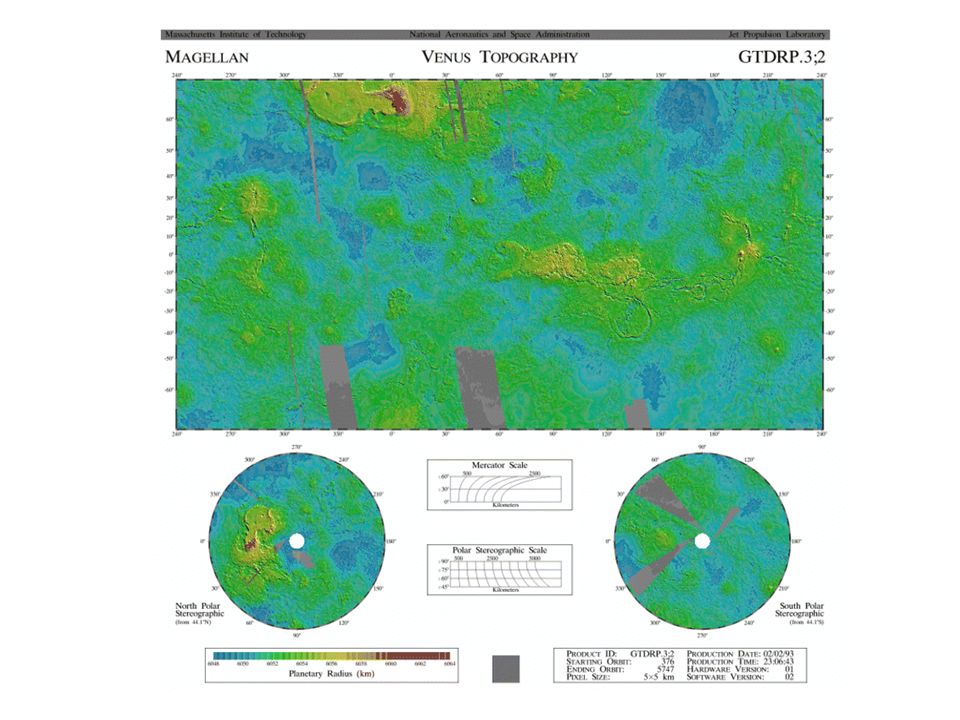
Wenus Struktury powierzchniowe
Three large impact craters with diameters ranging from 37 km (23 mi) to 65 km (40 mi) are visible in the fractured plains. Features typical of meteorite impact craters are also visible. Rough radar-bright ejecta surrounds the perimeter of the craters; terraced inner walls and large central peaks can be seen. Crater floors appear dark because they are smooth and have been flooded by lava. Domes of probable volcanic origin can be seen in the southeastern corner. The domes range in diameter from 1-12 km (0.6-7 mi); some have central pits typical of volcanic shields or cone Scientists nicknamed this type of volcano a tick. About 66 km (41 mi) across at the base, this volcano has a flat, concave summit 35 km (22 mi) in diameter. The sides of the volcano are characterized by radiating ridges and valleys. To the west, the rim of the volcano appears to have been breached by dark lava flows that emanated from a shallow summit pit (5.4 km/3.3 mi in diameter) and traveled west along a channel. The black square represents missing data. Seven circular domes can be seen on the eastern edge of Alpha Regio. They average 25 km (15 mi) in diameter with maximum heights of 750 m (2475 ft). Some scientists believe they are the result of eruptions of thick lava that flowed from a vent on level ground, resulting in an even lateral pattern of lava. The concentric and radial fracture pattern on the surface of the domes suggests that lava welled up inside the domes, causing the surface to stretch. This is a Magellan image of Crater Golubkina. The 30 km- (18 mi-) diameter crater is characterized by terraced inner walls and a central peak, typical of large impact craters on the Earth, Moon and Mars. The terraced inner walls take shape late in the formation of an impact crater, due to the collapse of the initial cavity created by the meteorite impact. The central peak forms due to the rebound of the inner crater floor. This crater is named after the Russian sculptor Anna Golubkina. This is a computer generated, perspective view of Crater Golubkina. Vertical exaggeration in this image is about 20 times The large fault-bounded trough in the center of the image was nicknamed Gumby (after an animated cartoon figure) by Magellan scientists. Located in the Lavinia region at the intersection of two tectonic trends, Gumby measures 5 km (3 mi) wide and m ( mi) deep. An example of one of the trends is the bright lines running E-W through Gumby's head. A second example is the bright lines running SW to NE through Gumby's legs and hips. The line of pits (by Gumby's elbow) suggests some igneous or volcanic activity may have accompanied the faulting.
 to 65 km (40 mi) are visible in the fractured plains. Features typical of meteorite impact craters are also visible. Rough radar-bright ejecta surrounds the perimeter of the craters; terraced inner walls and large central peaks can be seen. Crater floors appear dark because they are smooth and have been flooded by lava. Domes of probable volcanic origin can be seen in the southeastern corner. The domes range in diameter from 1-12 km (0.6-7 mi); some have central pits typical of volcanic shields or cone. Scientists nicknamed this type of volcano a tick. About 66 km (41 mi) across at the base, this volcano has a flat, concave summit 35 km (22 mi) in diameter. The sides of the volcano are characterized by radiating ridges and valleys. To the west, the rim of the volcano appears to have been breached by dark lava flows that emanated from a shallow summit pit (5.4 km/3.3 mi in diameter) and traveled west along a channel. The black square represents missing data. Seven circular domes can be seen on the eastern edge of Alpha Regio. They average 25 km (15 mi) in diameter with maximum heights of 750 m (2475 ft). Some scientists believe they are the result of eruptions of thick lava that flowed from a vent on level ground, resulting in an even lateral pattern of lava. The concentric and radial fracture pattern on the surface of the domes suggests that lava welled up inside the domes, causing the surface to stretch. This is a Magellan image of Crater Golubkina. The 30 km- (18 mi-) diameter crater is characterized by terraced inner walls and a central peak, typical of large impact craters on the Earth, Moon and Mars. The terraced inner walls take shape late in the formation of an impact crater, due to the collapse of the initial cavity created by the meteorite impact. The central peak forms due to the rebound of the inner crater floor. This crater is named after the Russian sculptor Anna Golubkina. This is a computer generated, perspective view of Crater Golubkina. Vertical exaggeration in this image is about 20 times. The large fault-bounded trough in the center of the image was nicknamed Gumby (after an animated cartoon figure) by Magellan scientists. Located in the Lavinia region at the intersection of two tectonic trends, Gumby measures 5 km (3 mi) wide and m ( mi) deep. An example of one of the trends is the bright lines running E-W through Gumby s head. A second example is the bright lines running SW to NE through Gumby s legs and hips. The line of pits (by Gumby s elbow) suggests some igneous or volcanic activity may have accompanied the faulting.")
10
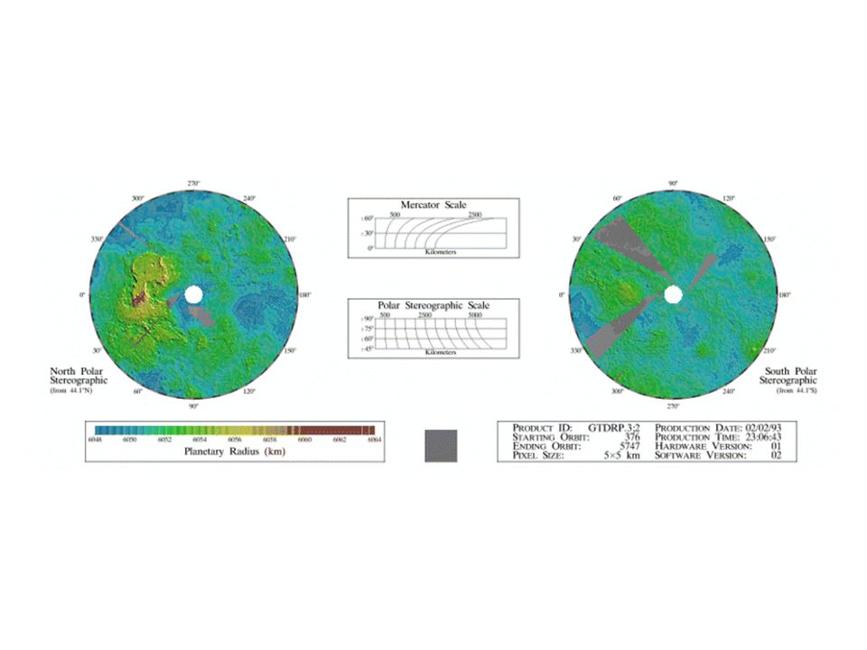
Wenus Struktury powierzchniowe Shefield,
Two groups of parallel features that intersect almost at right angles are visible. The regularity of this terrain caused scientists to nickname it "graph paper" terrain. The fainter lineations are spaced at intervals of about 1 km (.6 mi) and extend beyond the boundaries of the image. The brighter, more dominant lineations are less regular and often appear to begin and end where they intersect the fainter lineations. It is not yet clear whether the two sets of lineations represent faults or fractures, but in areas outside the image, the bright lineations are associated with pit craters and other volcanic features. Ovada region. The tectonic fabric of this region of Ovda Regio trends predominantly east-west. The large radar-dark areas are probably tectonically formed basins that have been filled in by fluid lava flows, thus presenting a smooth surface to the Magellan radar system. This region, roughly 100 km (60 mi) on a side, shows a gigantic structure known as a corona. Such features are thought to be the result of hot rising bodies of magma that reach the crust, and cause it to partially melt and collapse, generating volcanic flows and fault patterns that radiate from the central structure. Magellan acquired this view of Venus during its first mapping cycle around the planet in 1990 and 1991. This vertically exaggerated perspective image shows a 200-mile diameter corona on the southwest ridge of Alpha Regio. The roughly circular form and concentric ring of ridges are typical features of coronae. (Daniel Janes)
 and extend beyond the boundaries of the image. The brighter, more dominant lineations are less regular and often appear to begin and end where they intersect the fainter lineations. It is not yet clear whether the two sets of lineations represent faults or fractures, but in areas outside the image, the bright lineations are associated with pit craters and other volcanic features. Ovada region. The tectonic fabric of this region of Ovda Regio trends predominantly east-west. The large radar-dark areas are probably tectonically formed basins that have been filled in by fluid lava flows, thus presenting a smooth surface to the Magellan radar system. This region, roughly 100 km (60 mi) on a side, shows a gigantic structure known as a corona. Such features are thought to be the result of hot rising bodies of magma that reach the crust, and cause it to partially melt and collapse, generating volcanic flows and fault patterns that radiate from the central structure. Magellan acquired this view of Venus during its first mapping cycle around the planet in 1990 and This vertically exaggerated perspective image shows a 200-mile diameter corona on the southwest ridge of Alpha Regio. The roughly circular form and concentric ring of ridges are typical features of coronae. (Daniel Janes)")
11
Wenus Struktury powierzchniowe
Maat Mons volcano. (pionowa skala celowo przesadzona). This false-color view of the volcano Sif Mons was generated from Magellan SAR data and existing altimetry data. The image shows a region of the volcano just below the summit of the peak. A series of bright and dark lava flows is visible in the foreground. The brightest flows, which are relatively rough, are associated with the most recent volcanism in the region. The flows overlay older lava flows which are smoother and hence appear darker to the Magellan radar system. The volcano is 2 km (1.2 mi) high and 200 km (120 mi) in diameter. Vertical exaggeration in this image is about 20 times.
. This false-color view of the volcano Sif Mons was generated from Magellan SAR data and existing altimetry data. The image shows a region of the volcano just below the summit of the peak. A series of bright and dark lava flows is visible in the foreground. The brightest flows, which are relatively rough, are associated with the most recent volcanism in the region. The flows overlay older lava flows which are smoother and hence appear darker to the Magellan radar system. The volcano is 2 km (1.2 mi) high and 200 km (120 mi) in diameter. Vertical exaggeration in this image is about 20 times.")
15
Ziemia Średnica [km] Masa [kg] Vesc [km/s] Ok. Rot. [doba]
Ok. obie. [doba] Temp [K] a [JA] 12756 5.98*10^24 11.4 23.93 365.26 281 1 Ziemia Mass (kg) x 10^24 Diameter (km) Mean density (kg/m^3) Escape velocity (m/sec) Average distance from Sun (AU) Rotation period (length of day) (in Earth hours) Revolution period (length of year) (in Earth days) Obliquity (tilt of axis) (degrees) Orbit inclination (degrees) Orbit eccentricity Mean surface temperature (K) Maximum surface temperature (K) Minimum surface temperature (K) Visual geometric albedo Highest point on surface Mount Everest (over 8 km above sea-level) Atmospheric components % nitrogen, 21% oxygen, 1% argon Surface materials basaltic and granitic rock and altered materials
![Ziemia Średnica [km] Masa [kg] Vesc [km/s] Ok. Rot. [doba]](http://slideplayer.pl/slide/417133/1/images/15/Ziemia+%C5%9Arednica+%5Bkm%5D+Masa+%5Bkg%5D+Vesc+%5Bkm%2Fs%5D+Ok.+Rot.+%5Bdoba%5D.jpg "Ok. obie. [doba] Temp [K] a [JA] *10^ Ziemia. Mass (kg) x 10^24. Diameter (km) Mean density (kg/m^3) Escape velocity (m/sec) Average distance from Sun (AU) Rotation period (length of day) (in Earth hours) Revolution period (length of year) (in Earth days) Obliquity (tilt of axis) (degrees) Orbit inclination (degrees) Orbit eccentricity Mean surface temperature (K) Maximum surface temperature (K) Minimum surface temperature (K) Visual geometric albedo Highest point on surface Mount Everest (over 8 km above sea-level) Atmospheric components % nitrogen, 21% oxygen, 1% argon. Surface materials basaltic and granitic rock and altered materials.")
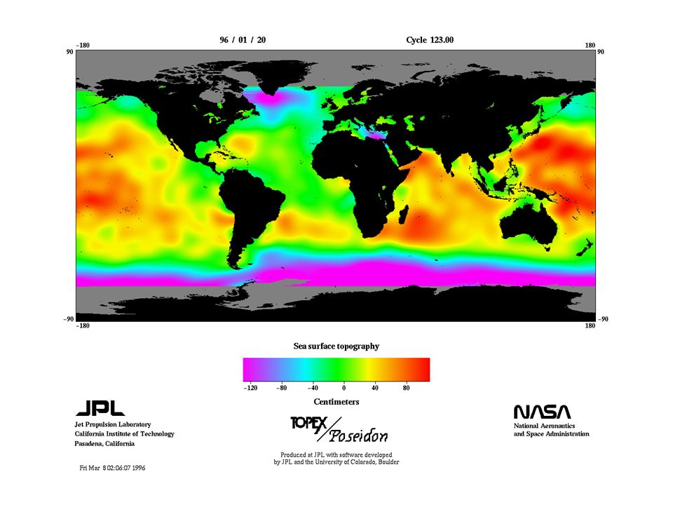
16
Współczesne sposoby monitorowania Ziemi
Satelita Ers-1

17
Współczesne sposoby monitorowania Ziemi

18
Współczesne sposoby monitorowania Ziemi

19
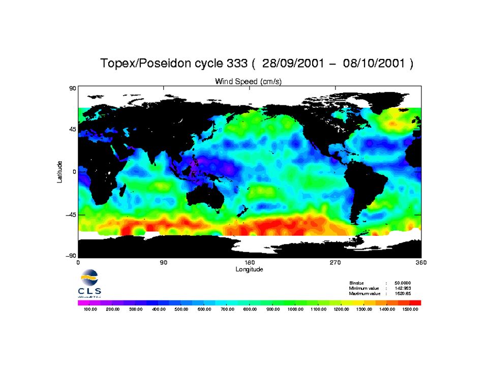
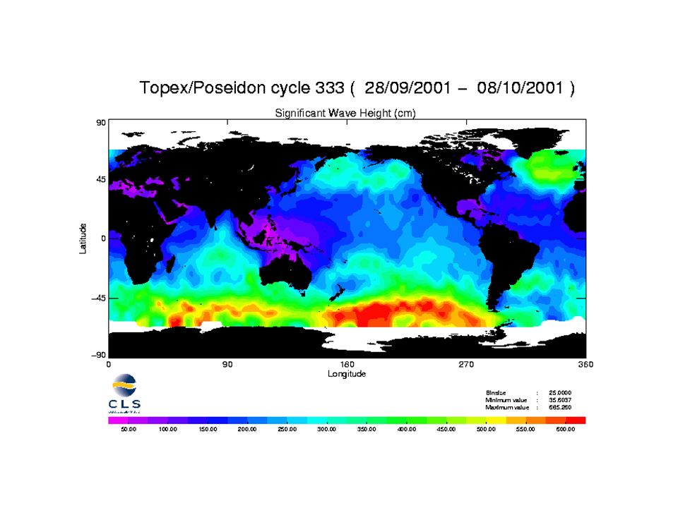
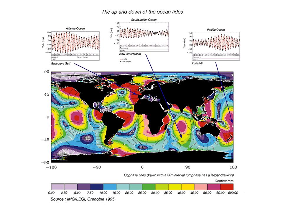
Współczesne sposoby monitorowania Ziemi
Pomiary altimetryczne

20
Pomiary altimetryczne

25
Ziemska atmosfera

26
Topografia mórz i lądów

27
Antarktyda

28
Ukształtowanie lądów Kamczatka Wulkan Fuiji

29
Komputerowa synteza obrazów 3D

30
Monitorowanie zmian środowiska naturalnego

31
Mars Widok z lądownika Wiking (1976) Średnica [km] Masa [kg]
Vesc [km/s] Ok. rot. [doba] Ok. obie [doba] Temp [K] a [JA] 6787 6.42*10^23 5.0 1.026 686.98 240 1.524 Mars Mass (kg) x 10^23 Diameter (km) Mean density (kg/m^3) Escape velocity (m/sec) Average distance from Sun (AU) Rotation period (length of day) (in Earth days) Revolution period (length of year) (in Earth days) Obliquity (tilt of axis) (degrees) Orbit inclination (degrees) Orbit eccentricity Maximum surface temperature (K) Minimum surface temperature (K) Visual geometric albedo Highest point on surface Olympus Mons (about 24 km above surrounding lava plains) Atmospheric components % carbon dioxide, 3% nitrogen, 1.6% argon Surface materials basaltic rock and altered materials This mosaic of Mars is composed of about 100 Viking Orbiter images. The images were acquired in 1980 during mid- northern summer on Mars. Crater Schiaparelli, left of center, is 461 km (277 mi) in diameter. The dark streaks with bright margins emanating from craters in the Oxia Palus region, in the upper left, are caused by erosion and deposition by the wind. Bright white areas to the south, including the Hellas impact basin at extreme lower right, are covered by carbon dioxide frost. Widok z lądownika Wiking (1976)
![Mars Widok z lądownika Wiking (1976) Średnica [km] Masa [kg]](http://slideplayer.pl/slide/417133/1/images/31/Mars+Widok+z+l%C4%85downika+Wiking+%281976%29+%C5%9Arednica+%5Bkm%5D+Masa+%5Bkg%5D.jpg "Vesc [km/s] Ok. rot. [doba] Ok. obie [doba] Temp [K] a [JA] *10^ Mars. Mass (kg) x 10^23. Diameter (km) Mean density (kg/m^3) Escape velocity (m/sec) Average distance from Sun (AU) Rotation period (length of day) (in Earth days) Revolution period (length of year) (in Earth days) Obliquity (tilt of axis) (degrees) Orbit inclination (degrees) Orbit eccentricity Maximum surface temperature (K) Minimum surface temperature (K) Visual geometric albedo Highest point on surface Olympus Mons (about 24 km above surrounding lava plains) Atmospheric components % carbon dioxide, 3% nitrogen, 1.6% argon. Surface materials basaltic rock and altered materials. This mosaic of Mars is composed of about 100 Viking Orbiter images. The images were acquired in 1980 during mid- northern summer on Mars. Crater Schiaparelli, left of center, is 461 km (277 mi) in diameter. The dark streaks with bright margins emanating from craters in the Oxia Palus region, in the upper left, are caused by erosion and deposition by the wind. Bright white areas to the south, including the Hellas impact basin at extreme lower right, are covered by carbon dioxide frost. Widok z lądownika Wiking (1976)")
32
Mars, struktury powierzchniowe
Nearly half of the Valles Marineris canyon system is visible here. The entire system extends over 4000 km (2490 mi), covering about one fifth the circumference of Mars. Some parts of the canyon run as deep as 7 km (4 mi) and as wide as 200 km (125 mi). Compared to Valles Marineris, the Grand Canyon on Earth seems quite small at 446 km (277 mi) long, 30 km (18 mi) wide and 1.6 km (1 mi) deep. This computer-generated perspective combines images and a surface topography model. The region shown is Ophir Chasma, part of the enormous Valles Marineris canyon system in the central equatorial region. This image shows slumping along the wall of the canyon. The region covered is about 200 km (124 mi) on a side. The depth of the canyon is about 6 km (4 mi).
, covering about one fifth the circumference of Mars. Some parts of the canyon run as deep as 7 km (4 mi) and as wide as 200 km (125 mi). Compared to Valles Marineris, the Grand Canyon on Earth seems quite small at 446 km (277 mi) long, 30 km (18 mi) wide and 1.6 km (1 mi) deep. This computer-generated perspective combines images and a surface topography model. The region shown is Ophir Chasma, part of the enormous Valles Marineris canyon system in the central equatorial region. This image shows slumping along the wall of the canyon. The region covered is about 200 km (124 mi) on a side. The depth of the canyon is about 6 km (4 mi).")
33
Mars, struktury powierzchniowe
Olympus Mons is the largest volcano on Mars. This shield volcano, similar to volcanoes in Hawaii, measures 624 km (374 mi) in diameter by 25 km (16 mi) high. It is 100 times larger than Mauna Loa on Earth. Located on the Tharsis Plateau near the equator, Olympus Mons is bordered by an escarpment. The caldera in the center is 80 km (50 mi) wide and contains multiple circular, overlapping collapse craters created by different volcanic events. The radial features on the slopes of the volcano were formed by overflowing lava and debris. This 3-dimensional image was created from several images of Olympus Mons. Each image was taken from a different spacecraft position and combined with a computer model of the surface topography to generate a perspective view. The final mosaic shows Olympus as it would be seen from the northeast. It's possible that volcanoes of such magnitude were able to form on Mars because the hot volcanic regions in the mantle remained fixed relative to the surface for hundreds of millions of years. Komputerowy model wulkanu na wybrzuszeniu Tharsis
 in diameter by 25 km (16 mi) high. It is 100 times larger than Mauna Loa on Earth. Located on the Tharsis Plateau near the equator, Olympus Mons is bordered by an escarpment. The caldera in the center is 80 km (50 mi) wide and contains multiple circular, overlapping collapse craters created by different volcanic events. The radial features on the slopes of the volcano were formed by overflowing lava and debris. This 3-dimensional image was created from several images of Olympus Mons. Each image was taken from a different spacecraft position and combined with a computer model of the surface topography to generate a perspective view. The final mosaic shows Olympus as it would be seen from the northeast. It s possible that volcanoes of such magnitude were able to form on Mars because the hot volcanic regions in the mantle remained fixed relative to the surface for hundreds of millions of years. Komputerowy model wulkanu na wybrzuszeniu Tharsis.")
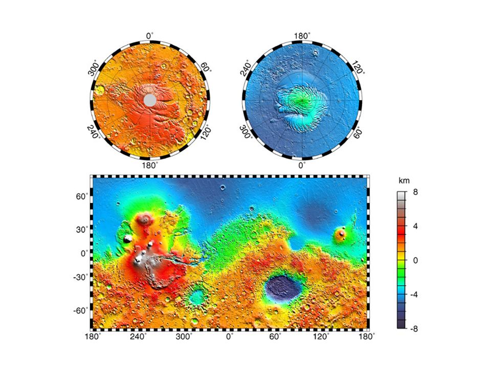
34
Mars, struktury powierzchniowe
Wybrzuszenie Tharsis Biblis patera Wydmy na marsjańskiej pustyni

35
Mars, obszary polarne

36
Mars, struktury powierzchniowe
Wyschnięte rzeki. Chmury wody i lodu

37
Mars, struktury powierzchniowe
Panorama – misja Viking Kamień badany przez misję Sojourner (robot) 1997. One of the rocks examined by Sojourner, the small robot cart deployed on Mars in Note the rounded texture of some parts of the rock and the small pits. These suggest that the rock formed from smaller pebbles rounded by erosion from flowing water. Heating later fused the pebbles into the rock we see. (Courtesy NASA/Tim Parker, JPL/ Mars Lander Program)
 One of the rocks examined by Sojourner, the small robot cart deployed on Mars in Note the rounded texture of some parts of the rock and the small pits. These suggest that the rock formed from smaller pebbles rounded by erosion from flowing water. Heating later fused the pebbles into the rock we see. (Courtesy NASA/Tim Parker, JPL/ Mars Lander Program)")
39
Marsjańskie księżyce Deimos Phobos
This computer mosaic of Deimos was made with images acquired from Viking Orbiter during one of its close approaches to the moon. The 15-km (9-mi) diameter Deimos circles Mars every 30 hours. Scientists speculate that Deimos and its companion moon Phobos were once passing asteroids that were pulled in by the gravity of Mars One of the most striking features on the 27 km (16 mi) diameter, irregularly shaped Phobos is the presence of grooves over most of its surface. The grooves seem to radiate in all directions from the giant Stickney crater and converge on the opposite side of the satellite at a region close to the Stickney antipode. The grooves are best developed near Stickney, where some measure 700 m (2307 ft) across and 90 m (294 ft) deep. However, most of the grooves have widths and depths in the m ( ft) and m ( ft) ranges, respectively. Phobos
 diameter Deimos circles Mars every 30 hours. Scientists speculate that Deimos and its companion moon Phobos were once passing asteroids that were pulled in by the gravity of Mars. One of the most striking features on the 27 km (16 mi) diameter, irregularly shaped Phobos is the presence of grooves over most of its surface. The grooves seem to radiate in all directions from the giant Stickney crater and converge on the opposite side of the satellite at a region close to the Stickney antipode. The grooves are best developed near Stickney, where some measure 700 m (2307 ft) across and 90 m (294 ft) deep. However, most of the grooves have widths and depths in the m ( ft) and m ( ft) ranges, respectively. Phobos.")
40
Układ Planetarny. Planety wewnętrzne

41
Układ Planetarny UP – jest układem płaskim można go zamknąć w płaskim pudle na kapelusze.

42
Misje do planet zewnętrznych
Voyager 1, Voyager 2 Start 1977 Misja planetarna Pioneer 10 was the first spacecraft to flyby Jupiter in Pioneer 11 followed it in 1974, and then went on to become the first probe to study Saturn in The Pioneers were designed to test the ability of spacecraft to survive passage thru the asteroid belt and Jupiter's magnetosphere. The asteroid belt was easy, but they were nearly fried by ions trapped in Jupiter's magnetic field. This information was crucial to the success of the Voyager missions. Pioneer 11's RTG power supply is dead. Its last communication with Earth was in November Pioneer 10 is still functioning (barely) but is no longer being tracked regularly due to budget cutbacks. The last data was received from it on 1997 March 31. They are heading off into interstellar space, the first craft ever to do so. As the first two spacecraft to leave our solar system, Pioneer 10 & 11 carry a graphic message in the form of a 6- by 9-inch gold anodized plaque bolted to the spacecraft's main frame. Launched on 5 April 1973, Pioneer 11 followed its sister ship to Jupiter (1974), made the first direct observations of Saturn (1979) and studied energetic particles in the outer heliosphere. The Pioneer 11 Mission ended on 30 September 1995, when the last transmission from the spacecraft was received. There have been no communications with Pioneer 11 since. The Earth's motion has carried it out of the view of the spacecraft antenna. The spacecraft cannot be maneuvered to point back at the Earth. It is not known whether the spacecraft is still transmitting a signal. No further tracks of Pioneer 11 are scheduled. The spacecraft is headed toward the constellation of Aquila (The Eagle), Northwest of the constellation of Sagittarius. Pioneer 11 will pass near one of the stars in the constellation in about 4 million years. Voyager 2 was launched August 20, 1977, onboard a Titan III/ Centaur rocket. Although Voyager 2 was launched 16 days before Voyager 1, it arrived at Jupiter four months later than its sister craft. The initial mission plan for Voyager 2 specified visits only to Jupiter and Saturn. The plan was augmented in 1981 to include a visit to Uranus, and again in 1985 to include a visit to Neptune. Voyager 2 completed both of those missions and is currently performing scientific experiments in interstellar space. The Galileo spacecraft and its Inertial Upper Stage booster rocket were deployed from the space shuttle Atlantis October 18, Shortly thereafter, the booster rocket fired and separated, sending Galileo on its six-year journey to the planet Jupiter. Upon its arrival at Jupiter in December 1995, Galileo will release a probe into the atmosphere so that scientists can survey the composition of the planet's clouds. The orbiter will relay probe information and will survey and photograph Jupiter and some of its major satellites. Pioneer 10, Pioneer 11 Start 1973 Misja planetarna Galileo, start 1989 Misja planetarna
 but is no longer being tracked regularly due to budget cutbacks. The last data was received from it on 1997 March 31. They are heading off into interstellar space, the first craft ever to do so. As the first two spacecraft to leave our solar system, Pioneer 10 & 11 carry a graphic message in the form of a 6- by 9-inch gold anodized plaque bolted to the spacecraft s main frame. Launched on 5 April 1973, Pioneer 11 followed its sister ship to Jupiter (1974), made the first direct observations of Saturn (1979) and studied energetic particles in the outer heliosphere. The Pioneer 11 Mission ended on 30 September 1995, when the last transmission from the spacecraft was received. There have been no communications with Pioneer 11 since. The Earth s motion has carried it out of the view of the spacecraft antenna. The spacecraft cannot be maneuvered to point back at the Earth. It is not known whether the spacecraft is still transmitting a signal. No further tracks of Pioneer 11 are scheduled. The spacecraft is headed toward the constellation of Aquila (The Eagle), Northwest of the constellation of Sagittarius. Pioneer 11 will pass near one of the stars in the constellation in about 4 million years. Voyager 2 was launched August 20, 1977, onboard a Titan III/ Centaur rocket. Although Voyager 2 was launched 16 days before Voyager 1, it arrived at Jupiter four months later than its sister craft. The initial mission plan for Voyager 2 specified visits only to Jupiter and Saturn. The plan was augmented in 1981 to include a visit to Uranus, and again in 1985 to include a visit to Neptune. Voyager 2 completed both of those missions and is currently performing scientific experiments in interstellar space. The Galileo spacecraft and its Inertial Upper Stage booster rocket were deployed from the space shuttle Atlantis October 18, Shortly thereafter, the booster rocket fired and separated, sending Galileo on its six-year journey to the planet Jupiter. Upon its arrival at Jupiter in December 1995, Galileo will release a probe into the atmosphere so that scientists can survey the composition of the planet s clouds. The orbiter will relay probe information and will survey and photograph Jupiter and some of its major satellites. Pioneer 10, Pioneer 11. Start Misja planetarna Galileo, start Misja planetarna")
43
Jowisz Misje Pioneer 1973, Voyager 1979, Galileo 1989 Średnica [km]
Masa [kg] Vesc [km/s] Ok. rot. [godz] Ok. obie [lata] Temp [K] a [JA] 1.9*10^27 59.5 9.8 11.86 120 5.203 Jowisz 1979 Mass (kg) x 10^27 Diameter (km) ,800 Mean density (kg/m^3) Escape velocity (m/sec) Average distance from Sun (AU) Rotation period (length of day in Earth hours) Revolution period (length of year) (in Earth years) Obliquity (tilt of axis) (degrees) Orbit inclination (degrees) Orbit eccentricity Mean surface temperature (K) (cloud tops) Visual geometric albedo Atmospheric components % hydrogen, 10% helium, .07% methane Rings Faint ring. Infrared spectra imply dark rock fragments. Voyager 2 was launched August 20, 1977 followed by the launch of Voyager 1 sixteen days later. Both spacecraft visited Jupiter and Saturn, with Voyager 2 continuing its journey to Uranus and Neptune. In spring 1990, Voyager 2 transmitted images looking back across the span of the entire solar system. Both Voyagers continue to explore interstellar space. The Galileo spacecraft and its Inertial Upper Stage booster rocket were deployed from the space shuttle Atlantis October 18, Shortly thereafter, the booster rocket fired and separated, sending Galileo on its six-year journey to the planet Jupiter. Upon its arrival at Jupiter in December 1995, Galileo will release a probe into the atmosphere so that scientists can survey the composition of the planet's clouds. The orbiter will relay probe information and will survey and photograph Jupiter and some of its major satellites. 1974 Misje Pioneer 1973, Voyager 1979, Galileo 1989 1995
![Jowisz Misje Pioneer 1973, Voyager 1979, Galileo 1989 Średnica [km]](http://slideplayer.pl/slide/417133/1/images/43/Jowisz+Misje+Pioneer+1973%2C+Voyager+1979%2C+Galileo+1989+%C5%9Arednica+%5Bkm%5D.jpg "Masa [kg] Vesc [km/s] Ok. rot. [godz] Ok. obie [lata] Temp [K] a [JA] *10^ Jowisz Mass (kg) x 10^27. Diameter (km) ,800. Mean density (kg/m^3) Escape velocity (m/sec) Average distance from Sun (AU) Rotation period (length of day in Earth hours) Revolution period (length of year) (in Earth years) Obliquity (tilt of axis) (degrees) Orbit inclination (degrees) Orbit eccentricity Mean surface temperature (K) (cloud tops) Visual geometric albedo Atmospheric components % hydrogen, 10% helium, .07% methane. Rings Faint ring. Infrared spectra imply dark rock fragments. Voyager 2 was launched August 20, 1977 followed by the launch of Voyager 1 sixteen days later. Both spacecraft visited Jupiter and Saturn, with Voyager 2 continuing its journey to Uranus and Neptune. In spring 1990, Voyager 2 transmitted images looking back across the span of the entire solar system. Both Voyagers continue to explore interstellar space. The Galileo spacecraft and its Inertial Upper Stage booster rocket were deployed from the space shuttle Atlantis October 18, Shortly thereafter, the booster rocket fired and separated, sending Galileo on its six-year journey to the planet Jupiter. Upon its arrival at Jupiter in December 1995, Galileo will release a probe into the atmosphere so that scientists can survey the composition of the planet s clouds. The orbiter will relay probe information and will survey and photograph Jupiter and some of its major satellites Misje Pioneer 1973, Voyager 1979, Galileo")
44
Struktury powierzchniowe
The colorful, wavy cloud pattern to the left of the Red Spot is a region of extraordinarily complex wave motion. This dramatic view of the Great Red Spot and its surroundings was taken February 25, 1979, when Voyager 1 was 9.2 million km (5.7 million mi) from Jupiter. An atmospheric system larger than Earth and more than 300 years old, the Great Red Spot remains a mystery. Swirling, storm-like features possibly associated with wind shear can be seen both to the left and above the Red Spot. This mosaic of the Great Red Spot was taken by the Voyager 2 spacecraft. It shows that the region changed significantly since the Voyager 1 encounter four months earlier. Around the northern boundary a white cloud is seen, which extends east of the region. The presence of this cloud prevents small cloud vertices from circling the spot in the manner seen in the Voyager 1 encounter. This large brown oval could be an opening in the upper cloud deck where warmer cloud levels may exist. Features of this sort are not rare on Jupiter and have an average lifetime of one to two years. Above the feature is the pale orange North Temperate Belt, bounded on the south by the high-speed North Temperate Current with winds of 120 m/s (260 mi/hr). The range to Jupiter, on March 2, 1979 when this photograph was taken, was 4.0 million km (2.5 million mi). The region just east of the Red Spot is seen here in greatly exaggerated color. The colors do not represent the true hues seen in the Jovian atmosphere but have been produced by special computer processing to enhance subtle variations in both color and shading. A close-up of one of the boundaries between the latitudinal cloud bands shows interaction between the bands.
 from Jupiter. An atmospheric system larger than Earth and more than 300 years old, the Great Red Spot remains a mystery. Swirling, storm-like features possibly associated with wind shear can be seen both to the left and above the Red Spot. This mosaic of the Great Red Spot was taken by the Voyager 2 spacecraft. It shows that the region changed significantly since the Voyager 1 encounter four months earlier. Around the northern boundary a white cloud is seen, which extends east of the region. The presence of this cloud prevents small cloud vertices from circling the spot in the manner seen in the Voyager 1 encounter. This large brown oval could be an opening in the upper cloud deck where warmer cloud levels may exist. Features of this sort are not rare on Jupiter and have an average lifetime of one to two years. Above the feature is the pale orange North Temperate Belt, bounded on the south by the high-speed North Temperate Current with winds of 120 m/s (260 mi/hr). The range to Jupiter, on March 2, 1979 when this photograph was taken, was 4.0 million km (2.5 million mi). The region just east of the Red Spot is seen here in greatly exaggerated color. The colors do not represent the true hues seen in the Jovian atmosphere but have been produced by special computer processing to enhance subtle variations in both color and shading. A close-up of one of the boundaries between the latitudinal cloud bands shows interaction between the bands.")
45
Zjawiska w atmosferze False-color picture of a convective thunderstorm 10,000 kilometers (6,218 miles) northwest of Jupiter's Great Red Spot was obtained by NASA's Galileo spacecraft on June 26, The white cloud in the center is a tall, thick cloud 1,000 kilometers (620 miles) across, standing 25 kilometers (15 miles) higher than most of the surrounding clouds. Its base extends off to the left and appears red in this representation. This red color indicates that the cloud base is very deep in the atmosphere, about 50 kilometers (30 miles) below the surrounding clouds. Most of the wisps and features in Jupiter's clouds are thick and thin ammonia clouds, forming at a pressure just less than Earth's sea level pressure. On Jupiter, water is the only substance to form a cloud at a depth where the pressure is about five times the Earth's sea level pressure. The red base of this thunderstorm is so deep that it can only be a water cloud. In 1979 NASA's Voyager spacecraft saw convective clouds of this type near the Great Red Spot. They erupted like this roughly once every 10 days and lasted a few days each. But Voyager's cameras could not allow the determination of the storms' altitude. It is thought that this storm is analogous to an Earth thunderstorm, with the cloud's high, bright, white portion comparable to the familiar anvil cloud on Earth. Whether any rain or snow is falling below this cloud is unknown, but there are indications that similar storms on Jupiter have lightning in them. The most dramatic difference between this storm and typical thunderstorms on Earth is the scale. The anvil of this storm is 1,000 km (620 miles) across and 75 km (46 miles) high. On Earth, the largest anvils are 200 km (124 miles) across and 18 km (11 miles) high. Light at different wavelengths penetrates to different depths in Jupiter's atmosphere before being reflected by clouds. In this image, red represents data taken with the 756 nanometer (nm) filter, where Jupiter's atmospheric gases are mostly transparent and the light penetrates deeply. Blue and green represent data taken with the 889 and 727 nm filters, respectively, where the gases in Jupiter's atmosphere absorb strongly, so only high clouds can reflect the light. Thus, the blue and green areas depict higher clouds, while the red areas show deep clouds as well as higher clouds. North is to the top of the picture, which was taken at a distance of 1.75 million kilometers (1.09 million miles) by Galileo's onboard solid state imaging camera system. The image covers an area approximately 9,000 by 7,000 kilometers (5,580 by 4,340 miles). JPL manages the Galileo mission for NASA's Office of Space Science, Washington, DC. This image and other images and data received from Galileo are posted on the World Wide Web, on the Galileo mission home page at . Background information and educational context for the images can be found at
 northwest of Jupiter s Great Red Spot was obtained by NASA s Galileo spacecraft on June 26, The white cloud in the center is a tall, thick cloud 1,000 kilometers (620 miles) across, standing 25 kilometers (15 miles) higher than most of the surrounding clouds. Its base extends off to the left and appears red in this representation. This red color indicates that the cloud base is very deep in the atmosphere, about 50 kilometers (30 miles) below the surrounding clouds. Most of the wisps and features in Jupiter s clouds are thick and thin ammonia clouds, forming at a pressure just less than Earth s sea level pressure. On Jupiter, water is the only substance to form a cloud at a depth where the pressure is about five times the Earth s sea level pressure. The red base of this thunderstorm is so deep that it can only be a water cloud. In 1979 NASA s Voyager spacecraft saw convective clouds of this type near the Great Red Spot. They erupted like this roughly once every 10 days and lasted a few days each. But Voyager s cameras could not allow the determination of the storms altitude. It is thought that this storm is analogous to an Earth thunderstorm, with the cloud s high, bright, white portion comparable to the familiar anvil cloud on Earth. Whether any rain or snow is falling below this cloud is unknown, but there are indications that similar storms on Jupiter have lightning in them. The most dramatic difference between this storm and typical thunderstorms on Earth is the scale. The anvil of this storm is 1,000 km (620 miles) across and 75 km (46 miles) high. On Earth, the largest anvils are 200 km (124 miles) across and 18 km (11 miles) high. Light at different wavelengths penetrates to different depths in Jupiter s atmosphere before being reflected by clouds. In this image, red represents data taken with the 756 nanometer (nm) filter, where Jupiter s atmospheric gases are mostly transparent and the light penetrates deeply. Blue and green represent data taken with the 889 and 727 nm filters, respectively, where the gases in Jupiter s atmosphere absorb strongly, so only high clouds can reflect the light. Thus, the blue and green areas depict higher clouds, while the red areas show deep clouds as well as higher clouds. North is to the top of the picture, which was taken at a distance of 1.75 million kilometers (1.09 million miles) by Galileo s onboard solid state imaging camera system. The image covers an area approximately 9,000 by 7,000 kilometers (5,580 by 4,340 miles). JPL manages the Galileo mission for NASA s Office of Space Science, Washington, DC. This image and other images and data received from Galileo are posted on the World Wide Web, on the Galileo mission home page at . Background information and educational context for the images can be found at")
46
Satelity Jowisza Io, Europa, Ganimed, Calisto
Data from the Pioneer 10 and 11 spacecraft suggested that a ring system around the giant planet Jupiter existed; this was confirmed by the Voyager flybys. This image was taken by Voyager 2 looking back at the rings from inside Jupiter's shadow. The ring is very bright because it is composed of fine dust, which scatters light efficiently in this viewing geometry. The picture shows the main ring 7000 km (4350 mi) wide, with a broad, thick "halo" inside it.
 wide, with a broad, thick halo inside it.")
47
Io's surface materials are rich in sulfur compounds
Io's surface materials are rich in sulfur compounds. Its volcanism is driven by tidal stresses induced by Jupiter and the next satellite out, Europa. Black lava lakes dot Io's surface, some of them as hot as 200 řC (392 řF). Io measures 3630 km (2178 mi) in diameter. Scientists believe that the surface of Europa is made up of ice mixed with rocky material. Complex ridges tracing cuspate forms testify to tectonic processes ongoing on this world. This image shows the area along the terminator extending into the south polar region. Europa, close in size to our Moon, is thought to have an ice surface 100 km (62 mi) thick, which overlies a silicate surface. The complex array of streaks indicates that the crust has been fractured. The lack of mountains or craters on its bright limb is consistent with an ice surface. In contrast to its icy neighbors, Ganymede and Callisto, Europa has few impact craters. One possible candidate is the small feature near the center of this image with radiating rays and a bright circular interior. The relative absence of features and low topography suggests the crust is young. The interior of Ganymede is thought to consist of a rocky core about the size of our Moon and to be surrounded by a thick covering of ice roughly equal in mass. Because the surface of Ganymede is made of ice, mountainous terrain would eventually collapse. Complex intersecting avenues of dark and bright terrains record multiple episodes in which the crust was fractured and reformed by icy volcanic fluids. About the size of Mercury, Ganymede is 5280 km (3168 mi) in diameter. This Voyager image is of Callisto, Jupiter's fourth large satellite. It is one of the Galilean satellites, so named because Galileo saw them when he first turned his telescope toward Jupiter. Callisto shows a surface saturated with impact scars attesting to the great age of this icy world. Callisto, composed of rock and ice, is covered with numerous impact craters. The largest of these is Valhalla Basin, a 2748-km (1650-mi) multi-ring impact basin near the top of the image. Craters on Callisto appear as bright and dark spots whose morphology changes. Newer craters appear as sharply defined bright and dark spots. Over time older craters appear as more diffuse splotches.
. Io measures 3630 km (2178 mi) in diameter. Scientists believe that the surface of Europa is made up of ice mixed with rocky material. Complex ridges tracing cuspate forms testify to tectonic processes ongoing on this world. This image shows the area along the terminator extending into the south polar region. Europa, close in size to our Moon, is thought to have an ice surface 100 km (62 mi) thick, which overlies a silicate surface. The complex array of streaks indicates that the crust has been fractured. The lack of mountains or craters on its bright limb is consistent with an ice surface. In contrast to its icy neighbors, Ganymede and Callisto, Europa has few impact craters. One possible candidate is the small feature near the center of this image with radiating rays and a bright circular interior. The relative absence of features and low topography suggests the crust is young. The interior of Ganymede is thought to consist of a rocky core about the size of our Moon and to be surrounded by a thick covering of ice roughly equal in mass. Because the surface of Ganymede is made of ice, mountainous terrain would eventually collapse. Complex intersecting avenues of dark and bright terrains record multiple episodes in which the crust was fractured and reformed by icy volcanic fluids. About the size of Mercury, Ganymede is 5280 km (3168 mi) in diameter. This Voyager image is of Callisto, Jupiter s fourth large satellite. It is one of the Galilean satellites, so named because Galileo saw them when he first turned his telescope toward Jupiter. Callisto shows a surface saturated with impact scars attesting to the great age of this icy world. Callisto, composed of rock and ice, is covered with numerous impact craters. The largest of these is Valhalla Basin, a 2748-km (1650-mi) multi-ring impact basin near the top of the image. Craters on Callisto appear as bright and dark spots whose morphology changes. Newer craters appear as sharply defined bright and dark spots. Over time older craters appear as more diffuse splotches.")
48
Aktywność wulkaniczna na księżycu Io
A volcanic explosion can be seen silhouetted against dark space over Io's brilliant limb. Solid material was blasted to an altitude of about 160 km (100 mi), requiring an ejection velocity from the volcanic vent of about 1920 km (1200 mi) per hour. Io appears to be far more volcanically active than Earth. The blue and white protrusion visible on the limb is an eruption of Volcano Loki. This picture of Io was taken by the Voyager 2 spacecraft in July 1979, during its closest approach to Jupiter's satellite.
, requiring an ejection velocity from the volcanic vent of about 1920 km (1200 mi) per hour. Io appears to be far more volcanically active than Earth. The blue and white protrusion visible on the limb is an eruption of Volcano Loki. This picture of Io was taken by the Voyager 2 spacecraft in July 1979, during its closest approach to Jupiter s satellite.")
49
Saturn Średnica [km] Masa [kg] Vesc [km/s] Ok. rot. [godz]
Ok. obie [lata] Temp [K] a [JA] 120660 5.69*10^26 35.6 10.2 29.46 88 9.539 Mass (kg) x 10^26 Diameter (km) Mean density (kg/m^3) Escape velocity (m/sec) Average distance from Sun (AU) Rotation period (length of day) (in Earth hours) Revolution period (length of year) (in Earth years) Obliquity (tilt of axis) (degrees) Orbit inclination (degrees) Orbit eccentricity Mean temperature (K) K (1 bar level) Visual geometric albedo Atmospheric components % hydrogen, 3% helium, .05% methane Rings Rings are 270,000 km in diameter, but only a few hundred meters thick. Particles are centimeters to decameters in size and are ice (some may be covered with ice); there are traces of silicate and carbon minerals. There are four main ring groups and three more faint, narrow ring groups separated by gaps called divisions. 1979
![Saturn Średnica [km] Masa [kg] Vesc [km/s] Ok. rot. [godz]](http://slideplayer.pl/slide/417133/1/images/49/Saturn+%C5%9Arednica+%5Bkm%5D+Masa+%5Bkg%5D+Vesc+%5Bkm%2Fs%5D+Ok.+rot.+%5Bgodz%5D.jpg "Ok. obie [lata] Temp [K] a [JA] *10^ Mass (kg) x 10^26. Diameter (km) Mean density (kg/m^3) Escape velocity (m/sec) Average distance from Sun (AU) Rotation period (length of day) (in Earth hours) Revolution period (length of year) (in Earth years) Obliquity (tilt of axis) (degrees) Orbit inclination (degrees) Orbit eccentricity Mean temperature (K) K (1 bar level) Visual geometric albedo Atmospheric components % hydrogen, 3% helium, .05% methane. Rings Rings are. 270,000 km in diameter, but only a few hundred meters thick. Particles are centimeters to decameters in size and are ice (some may be covered with ice); there are traces of silicate and carbon minerals. There are four main ring groups and three more faint, narrow ring groups separated by gaps called divisions")
50
Struktury powierzchniowe
This unique red oval cloud feature is visible in Saturn's southern hemisphere. The difference in color between the red oval and surrounding bluish clouds indicates that material within the oval contains a substance that absorbs more blue and violet light than the bluish clouds. The oval feature did not change in appearance for several months before this photo was taken on November 6, 1980 at a distance of 8,500,000 km (6,300,000 mi).
.")
51
Zjawiska w atmosferze Saturna
Zorze i wyładowania atmosferyczne na Saturnie Zorze polarne Wyładowania atmosferyczne

52
Satelity Saturna

53
This global mosaic of Enceladus was assembled from images acquired by Voyager 2 during its close flyby of Saturn's second large satellite. Although Enceladus shows an abundance of impact craters in some areas, the lava flows near the center of the disk contain many fewer craters and cut some craters in half. This confirms the multiple stages or episodes of volcanism that formed and reformed the icy body's surface. Tethys is approximately 1100 km (684 mi) in diameter and is densely populated with impact craters. One of these, above center, is surrounded by a hummocky ejecta blanket. Ithaca Chasma stretches from left center up toward the crater, covering three quarters of the circumference of Tethys. In this image of Saturn's fourth large moon, Dione, the trailing hemisphere is visible. This region was protected from billions of years of impact-gardening, which obliterated old surface features in the leading hemisphere. Icy fluids escaped to the surface through breaks in the crust and formed giant crisscrossing, wispy, bright marks on the exterior. Mimas, the innermost of Saturn's larger moons, was nearly shattered by a cataclysmic impact. From observing Mimas' crater Herschel, scientists speculate that the inner satellites of the outer planets have, in fact, been shattered and gravitationally reassembled many times in their geologic history. Herschel's walls are approximately 5 km (3.2 mi) high, parts of its floor measure 10 km (6.2 mi) deep, and its central peak rises 6 km (3.7 mi) above the crater floor. The diameter of this moon is 394 km (244 mi). Scientists believe that this small irregular satellite may once have been a piece of a larger satellite. Hyperion measures approximately 370 x 280 x 225 km (229 x 174 x 140 mi) and orbits outside of Titan.
 in diameter and is densely populated with impact craters. One of these, above center, is surrounded by a hummocky ejecta blanket. Ithaca Chasma stretches from left center up toward the crater, covering three quarters of the circumference of Tethys. In this image of Saturn s fourth large moon, Dione, the trailing hemisphere is visible. This region was protected from billions of years of impact-gardening, which obliterated old surface features in the leading hemisphere. Icy fluids escaped to the surface through breaks in the crust and formed giant crisscrossing, wispy, bright marks on the exterior. Mimas, the innermost of Saturn s larger moons, was nearly shattered by a cataclysmic impact. From observing Mimas crater Herschel, scientists speculate that the inner satellites of the outer planets have, in fact, been shattered and gravitationally reassembled many times in their geologic history. Herschel s walls are approximately 5 km (3.2 mi) high, parts of its floor measure 10 km (6.2 mi) deep, and its central peak rises 6 km (3.7 mi) above the crater floor. The diameter of this moon is 394 km (244 mi). Scientists believe that this small irregular satellite may once have been a piece of a larger satellite. Hyperion measures approximately 370 x 280 x 225 km (229 x 174 x 140 mi) and orbits outside of Titan.")
54
Pierścienie Saturna

55
Uran Średnica [km] Masa [kg] Vesc [km/s] Ok. rot. [godz]
Ok. obie [lata] Temp [K] a [JA] 51118 8.68*10^25 21.3 17.9 84 59 19.18 Uran Mass (kg) x 10^25 Diameter (km) Mean density (kg/m^3) Escape velocity (m/sec) Average distance from Sun (AU) Rotation period (length of day) (in Earth hours) Revolution period (length of year) (in Earth years)..84 Obliquity (tilt of axis) (degrees) Orbit inclination (degrees) Orbit eccentricity Mean temperature (K) Visual geometric albedo Atmospheric components % hydrogen, 15% helium, 2% methane (at depth) Rings Uranus has a system of narrow, faint rings. Ring particles are dark, and could consist of rocky or carbonaceous material. 1986
![Uran Średnica [km] Masa [kg] Vesc [km/s] Ok. rot. [godz]](http://slideplayer.pl/slide/417133/1/images/55/Uran+%C5%9Arednica+%5Bkm%5D+Masa+%5Bkg%5D+Vesc+%5Bkm%2Fs%5D+Ok.+rot.+%5Bgodz%5D.jpg "Ok. obie [lata] Temp [K] a [JA] *10^ Uran. Mass (kg) x 10^25. Diameter (km) Mean density (kg/m^3) Escape velocity (m/sec) Average distance from Sun (AU) Rotation period (length of day) (in Earth hours) Revolution period (length of year) (in Earth years)..84. Obliquity (tilt of axis) (degrees) Orbit inclination (degrees) Orbit eccentricity Mean temperature (K) Visual geometric albedo Atmospheric components % hydrogen, 15% helium, 2% methane (at depth) Rings Uranus has a system of narrow, faint rings. Ring particles are dark, and could consist of rocky or carbonaceous material")
56
Atmosfera, pierścienie i księżyce
Pierścienie drobiazg + pył

57
Miranda Miranda is the innermost of the large Uranian satellites. Its surface is composed mostly of rolling cratered plains that probably date back to the early evolution of the solar system when impact rates were extremely high. The other half is younger based on the fewer number of craters; it consists of complex sets of parallel and intersecting scarps and ridges. The bright V-shaped feature in the grooved area is Inverness Corona, and has been nicknamed the "Chevron". The huge, jagged canyon on the right limb is in the direction of Uranus itself.

58
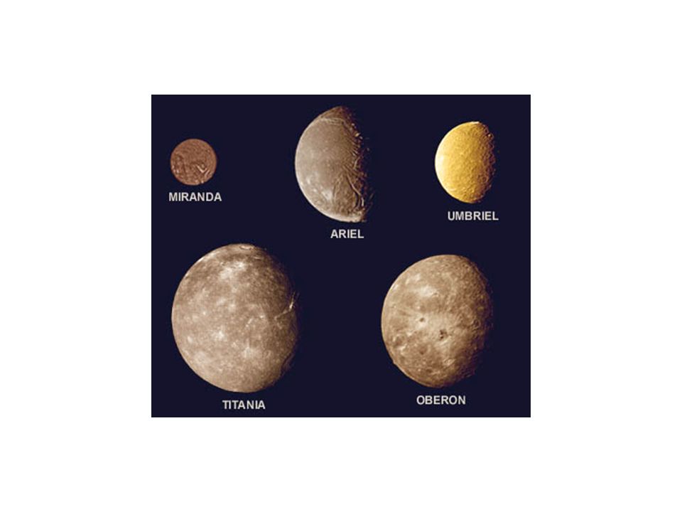
Ariel The complex terrain of Ariel is captured in this view of its southern hemisphere. Most of the surface consists of intensely cratered terrain transected by fault scarps and graben. Some of the largest graben, which can be seen near the terminator (at right), are partly filled with younger deposits that are less heavily cratered. Bright spots near the limb and toward the left are chiefly the rims of craters. Most of the brightly rimmed craters are too small to be resolved here, although one crater about 30 km (20 mi) in diameter is easy to spot near the center. Umbriel is an enigma. It has a surface albedo of only 10-15%, while the rest of the Uranian satellites found inside and outside Umbriel's orbit are much brighter. The process by which Umbriel's ancient cratered surface was darkened, leaving only a few bright icy white rings, remains a mystery. The abundance of impact craters and prominent global tectonic features on Titania are obvious in this image. The large fault valleys are some 1500 km (930 mi) long and 75 km (47 mi) wide. Near the bottom of the image the valley Messina Chasmata cuts through the impact crater Ursula (200 km or 124 mi in diameter). This high-resolution image was taken at a distance of 369,000 km (229,000 mi). Note that Titania's south pole is toward the left, since it rotates about Uranus' equator, approximately perpendicular to the ecliptic plane. This is the best spacecraft-acquired image of Uranus' outermost moon Oberon. Several large impact craters, surrounded by bright rays, are visible in this view. Near the center of Oberon's disk is a large crater with a bright central peak and a floor partially covered with black material. This may be icy, carbon-rich material that spilled onto the crater floor sometime after the crater formed. Another striking feature is a large mountain, about 6 km (4 mi) high, peeking out on the lower left limb. Oberon
, are partly filled with younger deposits that are less heavily cratered. Bright spots near the limb and toward the left are chiefly the rims of craters. Most of the brightly rimmed craters are too small to be resolved here, although one crater about 30 km (20 mi) in diameter is easy to spot near the center. Umbriel is an enigma. It has a surface albedo of only 10-15%, while the rest of the Uranian satellites found inside and outside Umbriel s orbit are much brighter. The process by which Umbriel s ancient cratered surface was darkened, leaving only a few bright icy white rings, remains a mystery. The abundance of impact craters and prominent global tectonic features on Titania are obvious in this image. The large fault valleys are some 1500 km (930 mi) long and 75 km (47 mi) wide. Near the bottom of the image the valley Messina Chasmata cuts through the impact crater Ursula (200 km or 124 mi in diameter). This high-resolution image was taken at a distance of 369,000 km (229,000 mi). Note that Titania s south pole is toward the left, since it rotates about Uranus equator, approximately perpendicular to the ecliptic plane. This is the best spacecraft-acquired image of Uranus outermost moon Oberon. Several large impact craters, surrounded by bright rays, are visible in this view. Near the center of Oberon s disk is a large crater with a bright central peak and a floor partially covered with black material. This may be icy, carbon-rich material that spilled onto the crater floor sometime after the crater formed. Another striking feature is a large mountain, about 6 km (4 mi) high, peeking out on the lower left limb. Oberon.")
61
Neptun Średnica [km] Masa [kg] Vesc [km/s] Ok. rot. [godz]
Ok. obie [lata] Temp [K] a [JA] 49528 1.02*10^26 23.3 19.1 164.8 48 30.06 Neptun Mass (kg) x 10^26 Diameter (km) Mean density (kg/m^3) Escape velocity (m/sec) Average distance from Sun (AU) Rotation period (length of day) (in Earth hours) Revolution period (length of year) (in Earth years) Obliquity (tilt of axis) (degrees) Orbit inclination (degrees) Orbit eccentricity Mean temperature (K) Visual geometric albedo Atmospheric components % hydrogen, 25% helium, 1% methane (at depth) Rings Rings are narrow, and contain concentrations of particles called ring arcs. 1989
![Neptun Średnica [km] Masa [kg] Vesc [km/s] Ok. rot. [godz]](http://slideplayer.pl/slide/417133/1/images/61/Neptun+%C5%9Arednica+%5Bkm%5D+Masa+%5Bkg%5D+Vesc+%5Bkm%2Fs%5D+Ok.+rot.+%5Bgodz%5D.jpg "Ok. obie [lata] Temp [K] a [JA] *10^ Neptun. Mass (kg) x 10^26. Diameter (km) Mean density (kg/m^3) Escape velocity (m/sec) Average distance from Sun (AU) Rotation period (length of day) (in Earth hours) Revolution period (length of year) (in Earth years) Obliquity (tilt of axis) (degrees) Orbit inclination (degrees) Orbit eccentricity Mean temperature (K) Visual geometric albedo Atmospheric components % hydrogen, 25% helium, 1% methane (at depth) Rings Rings are narrow, and contain concentrations of particles called ring arcs")
62
Feathery white clouds fill the boundary between the dark and light blue regions on the Great Dark Spot. The spiral shape of both the dark boundary and the white cirrus suggests a storm system rotating counterclockwise. Periodic small-scale patterns in the white cloud, possibly waves, are short-lived and do not persist from one Neptunian rotation to the next. Depicted here is the last face-on view of the Great Dark Spot that Voyager 2 made with its narrow-angle camera. The image was shuttered 45 hours before closest approach. This Voyager 2 high-resolution color image, taken 2 hours before closest approach, provides obvious evidence of vertical relief in Neptune's bright cloud streaks. These clouds were observed at 29 degrees North latitude near Neptune's east terminator. The linear clouds are stretched approximately along lines of constant latitude and the sun is toward the upper left. The sides of the clouds facing the sun are brighter than the surrounding cloud deck because they are more directly exposed to the sun. Shadows are visible on the side opposite the sun

63
The pink hue of Neptune's largest moon, Triton, is thought to result from a slowly evaporating layer of nitrogen ice. Triton is an oddity among moons in that its orbit is highly tilted to the plane of Neptune's equator, and it is in a retrograde orbit. These facts have led scientists to believe that Triton formed independently of Neptune and was later captured by Neptune's gravity. Tryton

64
Pluton Średnica [km] Masa [kg] Vesc [km/s] Ok. rot. [dni]
Ok. obie [lata] Temp [K] a [JA] 2300 1.29*10^22 1.1 6.39 247.7 37 39.53 Pluton Mass (kg) x 10^22 Diameter (km) Mean density (kg/m^3) Escape velocity (m/sec) Average distance from Sun (AU) Rotation period (length of day) (in Earth days) Revolution period (length of year) (in Earth years) Obliquity (tilt of axis) (degrees) Orbit inclination (degrees) Orbit eccentricity Mean temperature (K) Visual geometric albedo about 0.5 Atmospheric components perhaps methane and nitrogen Surface materials perhaps methane ice
![Pluton Średnica [km] Masa [kg] Vesc [km/s] Ok. rot. [dni]](http://slideplayer.pl/slide/417133/1/images/64/Pluton+%C5%9Arednica+%5Bkm%5D+Masa+%5Bkg%5D+Vesc+%5Bkm%2Fs%5D+Ok.+rot.+%5Bdni%5D.jpg "Ok. obie [lata] Temp [K] a [JA] *10^ Pluton. Mass (kg) x 10^22. Diameter (km) Mean density (kg/m^3) Escape velocity (m/sec) Average distance from Sun (AU) Rotation period (length of day) (in Earth days) Revolution period (length of year) (in Earth years) Obliquity (tilt of axis) (degrees) Orbit inclination (degrees) Orbit eccentricity Mean temperature (K) Visual geometric albedo about 0.5. Atmospheric components perhaps methane and nitrogen. Surface materials perhaps methane ice.")
65
Układ Pluton i Charon

Podobne prezentacje